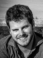
Bastien Vandendaele
Chercheur en télédétection forestière (Ing., Ph.D)
Développement de méthodes pour l'utilisation du lidar sur drone et de lidar mobile pour l'inventaire forestier amélioré
Université de Sherbrooke, Université de Liège (Gembloux Agro-BioTech)
Directeur: Richard Fournier, Philippe Lejeune
Codirecteur: Udayalakshmi Vepakomma
FORMATION
- PhD en Bioingénieurie et en Physique de la Télédétection, 2022 (Université de Sherbrooke & Université de Liège - Gembloux Agro-BioTech) - Thèse

- M.Sc en Bioingénieurie - Spécialisation en Gestion des Forêts et des Espaces Naturels, 2015 (Université de Liège - Gembloux Agro-BioTech)
- B.Sc. en Bioingénieurie - 2013 (Université de Liège)
- LinkedIn

PROJETS DE RECHERCHE
- Suivi de plantations de résineux par drone lidar (Northern Hardwood Research Institute)

- Digitalisation des produits forestiers en amont de la chaine de valeur Mitacs
 - Digital Timberland
- Extraction du volume de bois marchand à partir de lidar mobile (MLS) - (USherbrooke & ULiège) Article MLS

- Segmentation des arbres individuels à partir de données de drone lidar (ULS) et extraction d'attributs d'inventaire - AWARE UBC
 Article ULS
- Cartographie de peuplements forestiers par imagerie drone et multispectrale (FPInnovations)

- Cartographie de placettes forestières et extraction de paramètres dendrométriques à l'aide de lidar terrestre (TLS) (ULiège)
- ResearchGate

PUBLICATIONS
- Vandendaele B, Martin-Ducup O, Fournier RA, Pelletier G, Lejeune P. Mobile Laser Scanning for Estimating Tree Structural Attributes in a Temperate Hardwood Forest. Remote Sensing. 2022; 14(18):4522. https://doi.org/10.3390/rs14184522
- Vandendaele B, Fournier RA, Vepakomma U, Pelletier G, Lejeune P, Martin-Ducup O. Estimation of Northern Hardwood Forest Inventory Attributes Using UAV Laser Scanning (ULS): Transferability of Laser Scanning Methods and Comparison of Automated Approaches at the Tree- and Stand-Level. Remote Sensing. 2021; 13(14):2796. https://doi.org/10.3390/rs13142796
COMMUNICATIONS
- 10th International Conference on Agro-Geoinformatics & 43rd Canadian Symposium on Remote Sensing (CSRS) - Vandendaele*, B., Martin-Ducup, O., Fournier, R.A., Pelletier, G., Lejeune, P. (2022). Mobile Laser Scanning for Estimating Tree Structural Attributes in Temperate Hardwood Forests. , (oral presentation) Quebec City (QC). Icag-Csrs 2022

- 42nd Canadian Symposium of Remote Sensing (CSRS) - Vandendaele*, B., Fournier, R.A., Vepakomma, U., Pelletier, G., Lejeune, P. Martin-Ducup O. (2021). Investigating the use of UAV Laser Scanning (ULS) to derive individual tree attributes in a northern hardwood forest - A step towards better support for uneven-aged forest management (oral presentation). Crss-Sct 2021

- The Earth Observation (EO) Summit 2017 - Vandendaele*, B, Fournier, R.A., Vepakomma, U., Lejeune, P. (2017). Development of methods for the utilization of UAV based lidar for enhanced forest inventory, (poster presentation), Montreal (QC). EO 2017

- 24e Colloque annuel de la Chaire AFD - Vandendaele*, B., Martin-Ducup, O., Fournier, R.A., Pelletier, G., Lejeune, P. (2022). Atelier sur les applications du lidar en foresterie – Démonstration pratique sur le traitement des données ULS, TLS et MLS. (présentation orale), Abitibi. Colloque UQAT-UQAM

- Colloque TRIDIFOR - Vandendaele*, B., Martin-Ducup, O., Fournier, R.A., Pelletier, G., Lejeune, P. (2022). Mobile Laser Scanning for Estimating Tree Structural Attributes in a Temperate Hardwood Forest – Méthodes innovantes d’analyses de données 3D en forêts (oral presentation), France-Québec. TRIDIFOR
 Présentation
- Afcas - La preuve par l’image, édition 2022 - Vandendaele, B., (2022). À la lueur des cimes. Lauréat au concours de vulgarisation scientifique. La preuve par l'image

- 14e Colloque du Centre d’étude de la forêt - Vandendaele*, B., Fournier, R.A., Vepakomma, U., Pelletier, G., Lejeune, P. Martin-Ducup O. (2021). Investigating the use of UAV Laser Scanning (ULS) to derive individual tree attributes in a northern hardwood forest - A step towards better support for uneven-aged forest management.
- Bulletin de l’association Québécoise de télédétection (AQT), Volume 34 No.1 - Vandendaele, B., (2020). L’essor du drone-lidar en milieu forestier. Bulletin AQT

- AWARE Fourth Annual General Meeting, Toronto (ON) - Vandendaele*, B., Fournier, R.A., Vepakomma, U., Pelletier, G., Lejeune, P. (2020). Can UAV-based lidar provide consistent and accurate remote sensing data for enhanced forest inventory (oral and poster presentations).
- 12e Colloque du Centre d’étude de la forêt - Vandendaele*, B., Fournier, R.A., Vepakomma, U., Pelletier, G., Lejeune, P. (2018). Methods development to estimate tree structural attributes using lidar on an unmanned aerial vehicle (oral presentation), (poster presentation), Quebec city (QC).
- AWARE Third Annual General Meeting, Pointe Claire (QC) - Vandendaele*, B., Fournier, R.A., Vepakomma, U., Pelletier, G., Lejeune, P. (2018). Methods development to estimate tree structural attributes using lidar on an unmanned aerial vehicle (oral presentation).
- 11e Colloque du Centre d’étude de la forêt - Vandendaele*, B., Fournier, R.A., Vepakomma, U., Pelletier, G., Lejeune, P. (2017). Development of methods to estimate tree structural attributes using UAV-based lidar, Québec city (QC).
- Northern Hardwood Research Institute - Vandendaele*, B., Fournier, R.A., Vepakomma, U., Pelletier, G., Lejeune, P. (2017). Sustaining the hardwood resource value chain - assessing the capacity of UAV-based LiDAR to support operational-level forest inventory. The Forest Chain of Value , Edmundston (NB).
- AWARE Second Annual General Meeting, Edmundston (NB) - Vandendaele*, B., Fournier, R.A., Vepakomma, U., Pelletier, G., Lejeune, P. (2017). Methods development using UAV-based lidar to support Enhanced Forest Inventory in different forest ecosystems (oral and poster presentations), FPInnovations (QC).
- AWARE FirstAnnual General Meeting, Corner Brook (NF) - Fournier*, R.A., Vandendaele*, B., (2016). The use of terrestrial lidar for the estimation of tree structural attributes (oral presentation) - AWARE Project
GALERIE
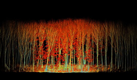
Lidar mobile collecté au sein d'une placette d'inventaire forestière (11.28 m de rayon) dans un peuplement de feuillus matures
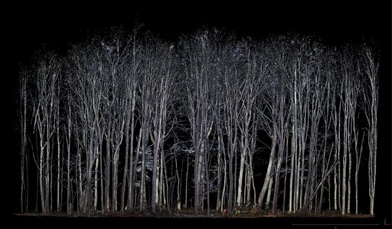
Lidar terrestre collecté au sein d'une placette d'inventaire forestière (11.28 m de rayon) dans un peuplement de feuillus matures
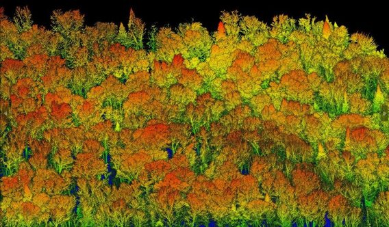
Drone lidar collecté au sein d'un peuplement irrégulier de feuillus matures


