


Bastien Vandendaele
Chercheur en télédétection forestière (Ing., Ph.D)
Développement de méthodes pour l'utilisation du lidar mobile et du lidar sur drone pour l'inventaire forestier amélioré
Spécialiste Lidar à Natural Resources Canada (NRCan) - Centre de Foresterie des Laurentides (QC)
FORMATION
- PhD en Bioingénieurie et en Physique de la Télédétection, 2022 (Cotutelle: Université de Sherbrooke & Université de Liège - Gembloux Agro-BioTech) - Thèse

- M.Sc en Bioingénieurie - Spécialisation en Gestion des Forêts et des Espaces Naturels, 2015 (Université de Liège - Gembloux Agro-BioTech)
- B.Sc. en Bioingénieurie - 2013 (Université de Liège)
PROJETS DE RECHERCHE
- Développement d’outils automatisés pour l’estimation du volume de bois marchand à partir de lidar mobile (MLS) en contexte opérationnel NRCan
- Développement de méthodes de caractérisation des combustibles forestiers à partir de lidar terrestre (TLS) NRCan
- Suivi de plantations de résineux par drone lidar (Northern Hardwood Research Institute)
- Digitalisation des produits forestiers en amont de la chaine de valeur Mitacs - Digital Timberland
- Extraction du volume de bois marchand à partir de lidar mobile (MLS) - (USherbrooke & ULiège) Article MLS
- Segmentation des arbres individuels à partir de données de drone lidar (ULS) et extraction d'attributs d'inventaire - AWARE UBC Article ULS
- Cartographie de peuplements forestiers par imagerie drone et multispectrale (FPInnovations)
- Cartographie de placettes forestières et extraction de paramètres dendrométriques à l'aide de lidar terrestre (TLS) (ULiège)
PUBLICATIONS
- Vandendaele B, Martin-Ducup O, Fournier RA, Pelletier G. 2024. Evaluation of mobile laser scanning acquisition scenarios for automated wood volume estimation in a temperate hardwood forest using quantitative structural models. Canadian Journal of Forest Research. 54(7): 774-792. https://doi.org/10.1139/cjfr-2023-0202
- Vandendaele, B., Pelletier, G., Hurley Poitras, P., Saunders, J., (2024). High-Density LiDAR Point Clouds in Precision Forestry. Insights from Seven Years of Research & Development. Northern Hardwoods Research Institute, Edmundston, NB. https://hardwoodsnb.ca/pdfviewer/high-density-lidar-point-clouds-in-precision-forestry/
- Vandendaele B, Martin-Ducup O, Fournier RA, Pelletier G, Lejeune P. Mobile Laser Scanning for Estimating Tree Structural Attributes in a Temperate Hardwood Forest. Remote Sensing. 2022; 14(18):4522. https://doi.org/10.3390/rs14184522
- Vandendaele B, Fournier RA, Vepakomma U, Pelletier G, Lejeune P, Martin-Ducup O. Estimation of Northern Hardwood Forest Inventory Attributes Using UAV Laser Scanning (ULS): Transferability of Laser Scanning Methods and Comparison of Automated Approaches at the Tree- and Stand-Level. Remote Sensing. 2021; 13(14):2796. https://doi.org/10.3390/rs13142796
COMMUNICATIONS
- ForestSAT2026 - Vandendaele*, B. Roussel, J.R., Havreljuk, F., Woods, M., Penner, M., Fournier, R.A., Bédard, S., and Coté, J.F., 2026. Operational Use of Mobile Laser Scanning for Estimating Tree Volume in Temperate Hardwood Forests. ForestSAT 2026
- TRIDIFOR2026 - Vandendaele*, B. Roussel, J.R., Havreljuk, F., Woods, M., Penner, M., Fournier, R.A., Bédard, S., and Coté, J.F., 2026. Estimation opérationnelle du volume de bois marchand en forêt feuillue à partir du lidar mobile. Présentation vidéo
- International Workshop - Richard Fournier & Patrick James, Université Laval - Vandendaele*, B. Roussel, J.R., Havreljuk, F., Fournier, R.A., Bédard, S., and Coté, J.F., 2026. Estimating Merchantable Wood Volume Using Mobile Laser Scanning Data in Mature Hardwood Stands.
- Plenary Session MRNF - Vandendaele*, B., Havreljuk, F., Fournier, R.A., Bédard, S., 2024. Utilisation du lidar mobile pour l’estimation du volume de bois sur pied en forêt feuillue - Cas d’étude à Sainte-Véronique (QC), MRNF (QC).
- Vermont Forest Industry Summit - Vandendaele*, B., Fournier, R.A., Pelletier, G. 2024. Precision Forestry – The Next Frontier (oral presentation), Bolton Valley.
- TRIDIFOR2023 - Vandendaele*, B. (2023). Évaluation de scénarios d'acquisition de lidar mobile pour l'estimation automatique du volume de bois dans une forêt de feuillus matures (présentation orale), France-Québec.
- Northern Hardwoods Conference (NHC) Vandendaele*, B., Martin-Ducup, O., Fournier, R.A., Pelletier, G., Lejeune, P. (2023). Embracing Innovation: Unleashing the Power of New Technologies in Precision Forest Inventory (oral presentation), Fredericton (NB).
- 10th International Conference on Agro-Geoinformatics & 43rd Canadian Symposium on Remote Sensing (CSRS) - Vandendaele*, B., Martin-Ducup, O., Fournier, R.A., Pelletier, G., Lejeune, P. (2022). Mobile Laser Scanning for Estimating Tree Structural Attributes in Temperate Hardwood Forests. , (oral presentation) Quebec City (QC). Icag-Csrs 2022
- 42nd Canadian Symposium of Remote Sensing (CSRS) - Vandendaele*, B., Fournier, R.A., Vepakomma, U., Pelletier, G., Lejeune, P. Martin-Ducup O. (2021). Investigating the use of UAV Laser Scanning (ULS) to derive individual tree attributes in a northern hardwood forest - A step towards better support for uneven-aged forest management (oral presentation). Crss-Sct 2021
- The Earth Observation (EO) Summit 2017 - Vandendaele*, B, Fournier, R.A., Vepakomma, U., Lejeune, P. (2017). Development of methods for the utilization of UAV based lidar for enhanced forest inventory, (poster presentation), Montreal (QC). EO 2017
- 24e Colloque annuel de la Chaire AFD - Vandendaele*, B., Martin-Ducup, O., Fournier, R.A., Pelletier, G., Lejeune, P. (2022). Atelier sur les applications du lidar en foresterie – Démonstration pratique sur le traitement des données ULS, TLS et MLS. (présentation orale), Abitibi. Colloque UQAT-UQAM
- TRIDIFOR2022 - Vandendaele*, B., Martin-Ducup, O., Fournier, R.A., Pelletier, G., Lejeune, P. (2022). Mobile Laser Scanning for Estimating Tree Structural Attributes in a Temperate Hardwood Forest – Méthodes innovantes d’analyses de données 3D en forêts (oral presentation), France-Québec. TRIDIFOR Présentation

- Afcas - La preuve par l’image, édition 2022 - Vandendaele, B., (2022). À la lueur des cimes. Lauréat au concours de vulgarisation scientifique. La preuve par l'image
- 14e Colloque du Centre d’étude de la forêt - Vandendaele*, B., Fournier, R.A., Vepakomma, U., Pelletier, G., Lejeune, P. Martin-Ducup O. (2021). Investigating the use of UAV Laser Scanning (ULS) to derive individual tree attributes in a northern hardwood forest - A step towards better support for uneven-aged forest management.
- Bulletin de l’association Québécoise de télédétection (AQT), Volume 34 No.1 - Vandendaele, B., (2020). L’essor du drone-lidar en milieu forestier. Bulletin AQT
- AWARE Fourth Annual General Meeting, Toronto (ON) - Vandendaele*, B., Fournier, R.A., Vepakomma, U., Pelletier, G., Lejeune, P. (2020). Can UAV-based lidar provide consistent and accurate remote sensing data for enhanced forest inventory (oral and poster presentations).
- 12e Colloque du Centre d’étude de la forêt - Vandendaele*, B., Fournier, R.A., Vepakomma, U., Pelletier, G., Lejeune, P. (2018). Methods development to estimate tree structural attributes using lidar on an unmanned aerial vehicle (oral presentation), (poster presentation), Quebec city (QC).
- AWARE Third Annual General Meeting, Pointe Claire (QC) - Vandendaele*, B., Fournier, R.A., Vepakomma, U., Pelletier, G., Lejeune, P. (2018). Methods development to estimate tree structural attributes using lidar on an unmanned aerial vehicle (oral presentation).
- 11e Colloque du Centre d’étude de la forêt - Vandendaele*, B., Fournier, R.A., Vepakomma, U., Pelletier, G., Lejeune, P. (2017). Development of methods to estimate tree structural attributes using UAV-based lidar, Québec city (QC).
- Northern Hardwood Research Institute - Vandendaele*, B., Fournier, R.A., Vepakomma, U., Pelletier, G., Lejeune, P. (2017). Sustaining the hardwood resource value chain - assessing the capacity of UAV-based LiDAR to support operational-level forest inventory. The Forest Chain of Value , Edmundston (NB).
- AWARE Second Annual General Meeting, Edmundston (NB) - Vandendaele*, B., Fournier, R.A., Vepakomma, U., Pelletier, G., Lejeune, P. (2017). Methods development using UAV-based lidar to support Enhanced Forest Inventory in different forest ecosystems (oral and poster presentations), FPInnovations (QC).
- AWARE FirstAnnual General Meeting, Corner Brook (NF) - Fournier*, R.A., Vandendaele*, B., (2016). The use of terrestrial lidar for the estimation of tree structural attributes (oral presentation) - AWARE Project
GALERIE
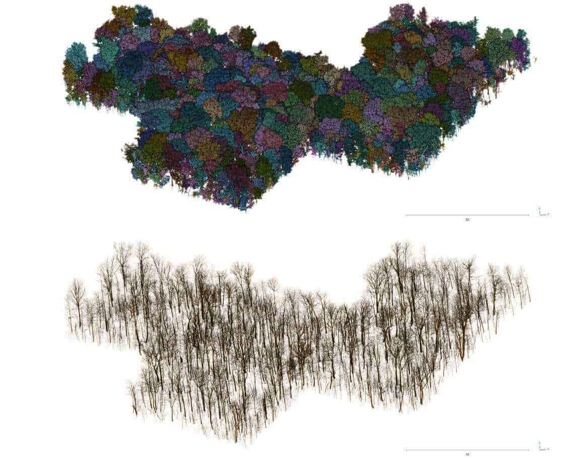
Arbres individuels segmentés à partir de données lidar mobile (haut) et modélisés à l'aide de modèles quantitatifs structuraux (QSM - bas) - peuplement de feuillus matures (2 ha)
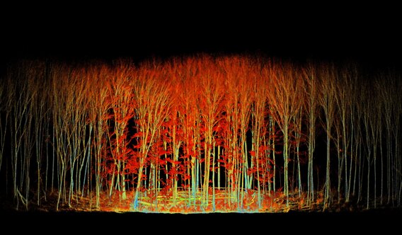
Lidar mobile collecté au sein d'une placette d'inventaire forestière (11.28 m de rayon) dans un peuplement de feuillus matures
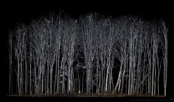
Lidar terrestre collecté au sein d'une placette d'inventaire forestière (11.28 m de rayon) dans un peuplement de feuillus matures
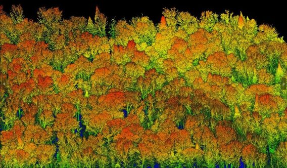
Drone lidar collecté au sein d'un peuplement irrégulier de feuillus matures